12
Jan 11

Llanfairfechan

Llanfairfechan

Population – 3,638

Post Office. – In village; branch office towards eastern end of Penmaenmawr ROad.

Tennis at Victoria Gardens, towards eastern end of the Promenade, and at the Receration Ground, near Moel Yacht Pond. Tennis tournaments are arranged weekly during the season.

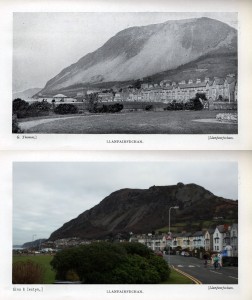
In it’s brief but merry course to the sea the little Afon Llanfairfechan dashes first through rocky, fern-clad gorges; then through the gradually widening valley in which the orignial village of Llanfairfechan stands and finally, passing under the coast road, it rattles past the modern resort called into visitors who appreciated this airy, healthy site on the verge of the sea yet within a stone’s-throw of the mountains. This charming contiguity of intrests is well illustrated by the stream which bubbles beside the main street of the village, for although its source is some 2,000 feet above the spot where it runs into the sea, yet it’s length is scarcely three miles. The eastern side of its valley terminates abruptly in the pominent headland know as Penmaenmawr Mountain; it’s western side falls away gradually in green, wooded hills above which giants of Snowdonia raise their heads to the sky.

The hills sufficiently far inland for thei majestic proportions to be seen and admired without the observer being oppressed with their too immediate proximity. Yet they are near enough for the ascent to begin at the door of the village post-office, and from any of them views of great beauty and variety may be had.

As the site has a gentle slope towards the sea, no great amount of moisture can remain upon the surface. Consequently the air is dry and bracing, and through the shelter afforded by neighbouring hills the climate is genial, as is demonstrated by fuchsias, myrtles, and other tender plants and shrubs – including the pale butterwort, a plant very sensitive to cold-flourishing all the year in open air.

The Sea Front at Llanfairfechan is unpretentious, but the bathing is safe and good, and the wide expanse of firm sand revealed by low tide forms a wonderland for children. There is a Green on which various games may be played and at either end of the Parade are public Tennis Courts and Bowling Green. A feature of even greater interest to the juvenile navigators – and their male relatives – is the Model Yacht Pond. It is regularly used by members of Liverpool and Wirral Model Yacht Clubs, and regattas are orginized during the season.

A feature distinguishing Llanfairfechan sea-front from many another is the View:-not the customary wide expanse of sea, but a charming panorama extending from the Great Orme’s Head across to Puffin Island, with it’s striped lighthouse, and then along the variegated coast of Anglesey to the tall roofs of Bangor, Penrhyn Castle rearing its battlement tower above the trees to the south-west, and then the eye travels round by the hills above Aber to remote Foel Fras and so round to the familiar scree-strewn face of “our mountain”.

It seems like Llanfairfechan, back in the day was the place to be! There’s an epic entry for the village in the book, and this is just an extract. I never thought of Llanfiarfechan to be a good place to be when going hill-walking, but I suppose the book is right, as from Llan you’ve got the whole of the Carneddau coming into play, before en counting the Snowdon massif. Very interesting to read this on Llanfairfechan. (Our North Wales – Northern Section book by Ward Lock & Co’s is dated 1930-1931)
07
Jan 11

Abersoch

Abersoch

Golf – 9-hole course. Season tickets: gentlemen 21s; ladies 10s. 6d. Monthly: gentlemen 15s; ladies 10s. Fortnightly: gentlemen; 10s.; ladies 7s. 6d. Weekly: gentlemen 7s. 6d; ladies 6s. Day: gentlemen, 2s; ladies 1s. 6d.

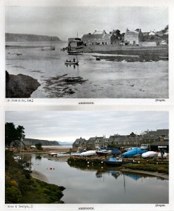
Abersoch, a small watering-place 3 miles from the Nanhoron Valley, stands on the shore of a pretty little bay. The extensive sands afford good bathing, but the tides recedes to a great distance. From full to half-tide, swimmers will find deep water under Benar Hill. Visitors must beware of being surrounded by the tide at this point. Those who care to spend a day fishing for mackerel may make arrangements for accompanying one of the numerous roomy boats belonging to the little port; but, on account of the currents, it is not advisable, even for skilled yachtsmen, to venture alone beyond the bay.

In the stream from which the village takes its name there is good trout fishing, execpt in dry seasons. Less than a mile from the shore are St. Tudwal’s Island and Lighthouse. Boats to visit them can be obtained.

Abersoch can be reached from Pwllheli by taking the tramcar to Llanbedrog and walking 3 miles.

This, so far is the most changed picture we’ve come across. The only thing (apart from Mynydd Tir y Cwmwd – the headland in the background) we had to go by was the two chimneys coming up from the furthest house, centre of the image. Everything else is totally different, and going from the text – grown quite a lot too!

I love the fact, that the only way to reach Abersoch back then, was walking! In today’s World, no such thing exists, shame really.


06
Jan 11

Llanberis Pass

Llanberis Pass

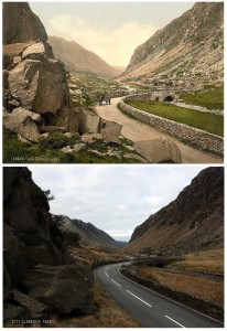
From the ‘resting place’ we begin the descent of the -Llanberis Pass, the finest motor mountain-road in Wales. The precipitous and craggy sides of the noble mountains press closely on each other and shut in the narrow pass. Shattered masses of every form, which have fallen from the heights, lie in strange confusion, and amid them the  Seiont, rushing and roaring, hastens its descent to the head of Llyn Peris.

Some two miles farther we reach the picturesque village of Nant Peris, formerly knows as Old Llanberis, and soon afterwards are running by the side of Llyn Peris, on the opposite shore of which are the Dinorwic slate quarries. Then we get abreast of the remains of Dolbadarn Castle. The consist only of a round tower, which probably does not date back many centuries, but the site is said to have been held by the Prince of North Wales in the sixth cantury. Beyond the ruin we arrive at the Royal Victoria Hotel, in modern Llanberis. At the foot of the hotel grounds is the lower terminus of the Mountain Railway.

Skirting Llyn Padarn, en route for Caernarvon from Llanberis, the remarkable manner in which the slate quarrymen have terraced the mountain slopes opposite is well seen. Then on the left the Cefndu wireless station comes in view and shortly after Carnarvon is reached.”

I’d sure have to agree that this road is the finest ‘motor mountain-road in Wales’. It sure is awesome. It’s my second favourite mountain route in the UK, second only to the epic A82 running through Glen Coe in the Scottish Highlands.

The Pass itself hasn’t changed much since the good old days, only a few big rocks been moved, but apart from that, it’s in top shape!


29
Aug 10

Beddgelert

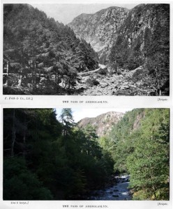
Aberglaslyn pass

Our new (old) awesome North Wales guide book doesn’t have a picture of Beddgelert itself. It does, however, tear apart the great legend of the place:

It seems cruel to spoil a pretty story, but truth must be told. About fifty years ago a writer is Welsh magazine showed that the legend was not founded on fact, and the Rev. A. Elvet Lewis, in a work published in 1899, entitled Bedd Gelert: Its facts, Fairies, and Folk-lore, gives wider publicity to its origin. He shows that the story, so far as it has local colour, is a growth of the nineteenth century; that before 1798 it was unknown in the neighbourhood; and that it was, in all probability, imported from South Wales by a certain David Prichard, who migrated north and became the first landlord of the Royal Goat Hotel at Beddgelert. Prichard came stocked with good stories from the southand among them was that of ‘the man who killed his greyhound’. He it was who fitted this particular folk-tale to the scene, and the dog to the name of Gelert; he who told the story to Spencer, the author of the familiar ballad; and he who, with the artistic completeness of the born myth-maker, aided by the parish clerk and another, raised the stone now exhibited on the spot known as the grave.

So there it goes. Legend gone. The tomb stone is still there though.
And a charming walk from there still takes you to the Aberglaslyn pass, just as all those years ago, and it even looks quite the same, except the trees have grown a lot.

…looking back from the romantic Pont Aberglaslyn we have an uninterrupted view of naked brown precipices rising to the sky beyond the fir trees and the dashing stream at our feet. (Teas and refreshments may be obtained at the bridge.)


28
Aug 10

Menai Bridge

Menai Bridge

Tolls: Foot passengers, 1d.; motor-cycle and side-car, 6d.; motor-cars seating no more than 3 persons, 1s 2d., seating 3-6 persons 1s. 9d. All these tolls are for the double journey.

This bridge, which spans the strait at a point 1 1/2 miles from Bangor station, carries the road.

Up to the beginning of the nineteenth century, ferries, five in number, afforded the only means of communication with Anglesey; but owing to the inconvenience and danger to which travellers were exposed, the attention of the Government was seriously directed to the matter, and, Telford’s plans for the bridge having been approved by Parliament, its construction was begun in 1818, and on January 30, 1826, it was opened. Its actual cost was £120,000, and the sum of £26,577 was awarded to the owners of the superseded ferries. The roadway is 100 feet above the surface of the water at the highest tides; the distance between the points of suspension is 560 feet, and the total length of the roadway is said to be 1,000 feet. Only four fatal accidents occurred among the workmen engaged in the erection of the bridge, and those who lost their lives represented the four nationalities included in the United Kingdom.

Coincidence? I don’t think so! In any case useful trivia in case this question ever came up in the Thursday pub quiz. Also, the house by the bridge looks totally awesome now!


27
Aug 10

Caernarfon

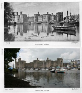
Caernarfon castle through ages

or Carnarvon, as per our awesome guide, had to be the first stop in our retro-project.

Caer-ar-fon “the fortress opposite Anglesey” stands just within the western entrance to the Menai Strait, at the mouth of the river Seiont. It is the ancient “metropolis of the hills” – the chief town in that mountainous stronghold known as Eryri, and the best view of the town (that from the path leading to the Baths) still shows the stout little fortress backed by the wild and rugged giants of Snowdonia. Carnarvon is the best modern representative of the British fortress Caer Seiont, and of the Roman military station, Segontium, and in position, beauty and historic associations there are few towns, if any, in Wales to compare with it.

Yes, yes, that’s quite right. In fact, there are few towns altogether, not only in Wales, that can compare to Caernarfon. Also, the seagulls. The guide doesn’t mention them, but we love them, and love to be woken up by their cries early in the morning. (Yes, we.) So what does the guide have to say about the castle?

Admission – sixpence; children 3d.; parties over 20, 3d each.
Open daily 10-8 or dusk, Sundays from 12 noon to 6 or dusk if earlier.
Entrance by King’s Gate, on north side.

With the exception of that in Alnwick, in Northumberland, Carnarvon Castle is “the finest in Great Britain”. Dr. Johnson, who visited in 1774, observed in his diary: “The Castle is an edifice of stupendous magnitude and strength. To survey this place would take much time – I did not think there had been such buildings; it surpassed my ideas.”

Seriously, a sixpence? The prices have gone horribly up, haven’t they? They made me pay like a fiver. Worth it though. Specially up the towers – everybody should do that. And who ever heard of Alnwick?